Real-time global OSINT intelligence platform built in C++ with a self-learning meta-system at its core. 53 live data sources fused onto an interactive 3D globe, including passive HF radio spectrum monitoring on military bands. Pattern Discovery Engine learns per-region baselines, detects multi-source convergence, and generates probabilistic threat predictions. Self-grading prediction ledger evaluates its own forecasts, tracks hit rates per region, and reinforces what works. Pure native app. No cloud. Your data never leaves your machine.
Meridian fuses aviation, maritime, conflict, environmental, and news intelligence into a single real-time 3D view. The meta-system beneath it learns from every event it sees, adapting thresholds, source weights, and severity formulas per region until predictions become genuinely accurate for the world as it is now.
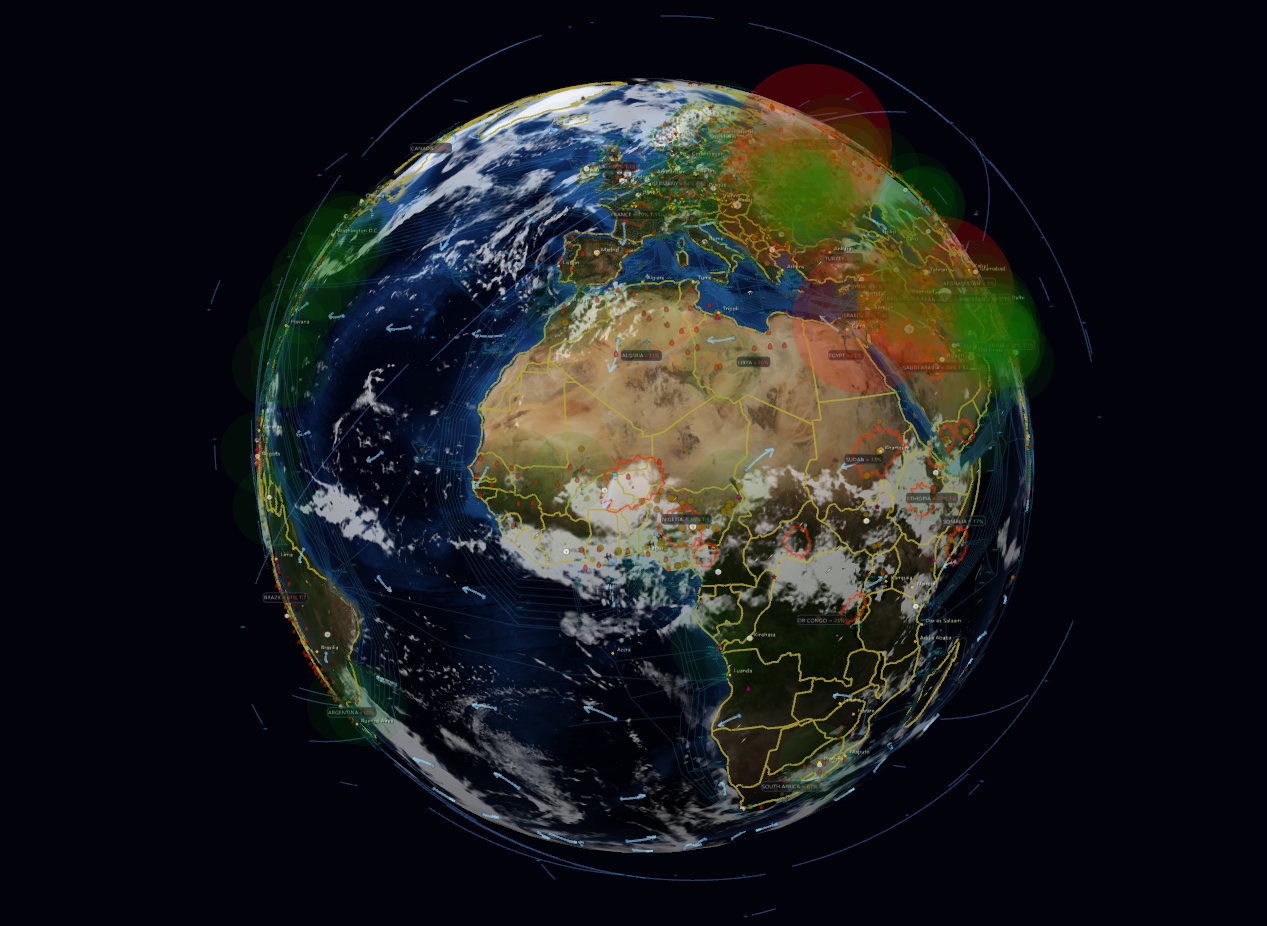
Satellite imagery tiles, smooth camera orbit, zoom from full globe to 1.5-degree telephoto FOV. Cockpit first-person view mode for immersive monitoring. Clean mode for data-focused analysis. Day/night terminator with real-time sun position. Cloud overlay layer. Milky Way skybox with Moon rendering. Smart icon clustering that never hides military aircraft. Cinematic auto-pan mode for presentations. Conflict heatmap overlay. Missile impact animations with separate ballistic and cruise trajectories. Tsunami wave animations. Manual map markers with persistent storage.
ADS-B aircraft tracking across 5 independent feeds with cross-source corroboration to validate military activity. AIS ship tracking via WebSocket. RSS news across 34+ feeds including CGTN, RT, and Xinhua for comparative narrative analysis alongside Western outlets. Telegram OSINT channels, Reddit, earthquake/seismic, NASA FIRMS fire detection, GDACS disaster alerts, conflict zones, weather/wind, lightning, air quality, submarine cables, BGP route monitoring, and IoT sensor networks. Every source weighted by region-specific reliability scores that the system learns over time.
Every event classified by severity, magnitude, proximity to critical infrastructure, and regional density. Four-weight scoring engine outputs None/Low/Medium/High/Critical threat levels with configurable thresholds.
Six independent AI pipelines: geolocation, threat analysis, SITREP, news summary, translation, and pattern synthesis. Each can be assigned a different LLM provider independently: local 0.8B (fast), local 4B (quality), Claude API, or any OpenAI-compatible endpoint. Per-article LLM tension scoring assigns each news item a 0-100 severity score stored in SQLite, so the system accumulates institutional memory rather than re-scoring on every run. News reader in newspaper mode with full-screen article popups and sort by intelligence priority. Reality Check pipeline performs adversarial LLM fact-checking with per-source credibility scoring (0-100). Narrative Analysis compares Western, Russian, and Chinese framing of the same events. LLM judge grades the system's own predictions so accuracy improves automatically.
GPS jamming-to-attack correlation predicts strikes before they happen. Cable sabotage detection: ship-cable loitering flags vessels stationary within 1km of a cable for 30+ minutes, 20+km offshore, combined with AIS-dark detection and news mention correlation for three-layer verification. Civilian air avoidance detection - a sustained drop in civilian flights over a region (below its learned per-hour baseline) fires as an early warning signal, because crews reroute around active closures and hazards before any official report. Per-country tension index from five signal types. 45+ conflict zones auto-updated from Wikipedia. LLM threat vector extraction reads articles, identifies origin and target locations, and renders directional arrows on the globe. Conflict intensity heatmap overlay. Kinetic-context-aware predictions: the system does not generate missile predictions in regions with no relevant history.
Every country scored 0-100 from five international indices (Freedom House, EIU, V-Dem, RSF, Transparency International). Trend arrows show 10-15 year trajectory. Click any country for full breakdown, tension score, and geopolitical context.
Five country-specific military alert systems integrated directly: Israel (Pikud HaOref real-time rocket alerts), Japan (J-Alert missile warnings), South Korea civil defense, Taiwan NCDR, and Canada Alert Ready. Plus FEMA IPAWS for the US and CAP/MeteoAlarm aggregating 30+ European countries via WMO. Two independent Ukraine air raid alert feeds run simultaneously. NOAA tsunami warnings, IAEA nuclear events, WHO/ProMED disease outbreaks, internet outage detection (IODA + Cloudflare), BGP route change monitoring for cable/shutdown detection, maritime piracy reports, and travel advisories. All color-coded by severity and plotted on the globe within seconds of broadcast.
Global webcam integration with hotspot-based discovery prioritized around conflict zones. Click any webcam icon on the globe to open a live view directly in the detail panel. Visual reconnaissance tool: pin any location on the globe, query nearby webcams, and auto-composite their images into a single reference snapshot for the area. Persistent cache ensures fast loading across sessions.
AI-powered behavioral profiles of world leaders built from accumulated news analysis. Tracks promises vs outcomes, logs contradictions with dates and quotes, monitors rhetorical patterns, and scores credibility (0-100). Profiles evolve over time as new articles are processed - the system builds institutional memory.
Real-time sanctions tracking (OFAC + EU) for 22+ countries and entities. Comprehensive geopolitical context for 30+ nations: alliances, adversaries, bloc affiliations, strategic capabilities. Country popups show sanctions status, alliance networks, and neighbor tension scores. Travel advisory integration from the US State Department displayed alongside country risk.
Six search modes in one widget: Location (city/country with globe pan), Planes (callsign or flight ID), Ships (MMSI or vessel name), Energy (power plant name), Datacenters, and All Entities. Type-ahead suggestions populated from live data. Covers the entire tracked dataset - if it's on the globe, you can find it by name.
Live-updated occupied and contested territory polygons from the DeepState mapping project, synced directly from their public GitHub repository. Overlaid on the globe as a toggleable layer. Updates automatically as the frontline changes, without any manual intervention.
AirspaceMonitor uses polygon-based country detection against a full ICAO hex database to identify military aircraft over any nation. Alliance and treaty map (NATO, Five Eyes, CSTO, SCO, and more) with override JSON for custom classifications. Tension-weighted severity scoring draws from a real tension database. Military callsign detection runs across all five ADS-B sources simultaneously. Deployment surge detection fires when military transport activity in a region spikes above its rolling 7-day baseline.
The Pattern Discovery Engine divides the world into 2x2 degree cells and learns per-cell baselines using Welford's algorithm with 24 separate time buckets per cell - one per hour of day - so the system knows that 3am quiet is different from 3pm quiet. Bayesian-weighted convergence scoring adapts over time. Seven scenario templates (troop buildup, economic warfare, humanitarian crisis, and more) match against live signal patterns. Predictive alerts from ~30 learned source-pair conditional probabilities. Self-grading prediction ledger: an LLM judge evaluates each forecast after its time window expires. Hit/miss/partial/inconclusive verdicts feed back into convergence thresholds that tighten or relax per region automatically. All learned data decays weekly so the system adapts to changing conditions rather than freezing on stale history.
Passive monitoring of public KiwiSDR receivers worldwide on military HF bands: NATO STANAG, USAF HFGCS primary and backup, Russian Navy and Military, maritime distress, and aviation weather. Baseline-subtracted sigma scoring flags unusual transmitter activity per station and band. Spikes above 2.5 sigma generate alerts; above 4 sigma trigger High-threat classifications. HF corroboration engine retroactively links high-sigma radio activity to conflict events that occur within receiver range, building a per-cell correlation count. When a conflict event fires in a cell with prior HF corroboration, its convergence score is automatically boosted. Integrates into the main alert panel as "HF Radio Spikes" and feeds the Pattern Engine as an additional convergence signal.
Real-time dashboard tracking every prediction the system has ever made. Five overview counters: total, verified, hit rate, pending, and active regions. Active predictions panel shows live countdowns with source type color-coding (Anomaly, Convergence, Predictive, Template, Intel Estimate, Chain). Verdict panel displays completed judgments (hit/miss/partial/inconclusive) with reason text from the LLM judge. Regional accuracy breakdown table ranks every region-metric pair by prediction volume and hit rate. Rolling accuracy trend graph plots accuracy over the last 200 verdicts in a 10-verdict rolling window so you can see if the system is improving or degrading over time.
Click any aircraft or ship to begin tracking it. The system logs every position update as a timestamped waypoint with speed and heading data, draws a color-coded trail on the globe, and flags "SIGNAL LOST" if the entity goes dark. The Intelligence Tracker overlay opens a full-screen analysis workspace: left panel lists all tracked entities with waypoint counts, right panel shows entity details including registration, aircraft type, MMSI, squawk code, OpenSky-derived departure airport, estimated destination, airline, and an inline aircraft or ship photo. Route log scrolls the full position history with reverse-geocoded place names at each waypoint. Tracked entities persist across restarts.
Financial market monitoring correlated against live intelligence signals. Tracks key commodities (gold, WTI and Brent oil, natural gas, wheat, corn) and defense equities (Lockheed Martin, RTX, Northrop Grumman, General Dynamics, BAE Systems, Rheinmetall, Thales, Safran, Elbit Systems) via Yahoo Finance. When commodities spike 2.5%+ alongside conflict signals in linked regions, an Economic-Conflict correlation alert fires. Defense delta analysis compares defense stocks against their country market index: a positive delta in a high-tension region is a conflict premium signal; a spike without accompanying escalation is a leading indicator. All market events appear on the globe at their geographic nexus.
Live status panel for every data source in the platform. Shows connection status (Connected, Connecting, Offline, Error, Rate Limited), total fetch count, total items ingested, error count and error rate, time since last successful fetch, and poll interval. Stale sources are highlighted in amber when last fetch age exceeds three times their polling interval. Sources are sorted by priority: errors first, then connected, then disabled. Lifetime aggregate counters at the top give a quick health snapshot across all feeds.
Each source runs on its own polling timer or WebSocket stream. Green dots are live streaming, blue are periodic polling. Per-source reliability scores are learned per region over time.
Continuous background analysis across every region on earth. All processing runs locally on your machine. The Pattern Discovery Engine, Bayesian convergence scorer, scenario templates, and Prediction Verifier form a self-correcting intelligence loop. Day one uses hardcoded defaults. After weeks of operation, it has learned what actually works in each part of the world.
Flags when multiple distinct signal types appear in the same 2x2 degree grid cell within 24 hours. Bayesian-weighted scoring means each signal's contribution is scaled by its learned reliability for that region. The convergence threshold itself is dynamic: if missile predictions only reach 40% accuracy at 3 signals but 55% at 5, the system raises the bar automatically.
Rolling baselines per cell using Welford's algorithm. Flags density spikes (more events than usual) and unusual signal types (never-before-seen layers in a region). Configurable sigma sensitivity.
Multi-factor scoring for every event: type severity (35%), magnitude (25%), proximity to critical infrastructure within 50km (25%), and regional event density (15%). Outputs None/Low/Medium/High/Critical with tunable weights.
72-hour rolling window, 24 time buckets. Detects periodic recurrence (autocorrelation > 0.65) and escalation trends (regression slope > 0.15 SE).
Conditional probability learning across ~30 constrained source pairs triggers predictive alerts when learned co-occurrence patterns are met. 6-hour forecast horizon with confidence scoring.
Tracks when GPS interference precedes missile or drone attacks. Builds per-region correlation tables with lead time statistics. When jamming fires in a high-correlation zone, it warns before the strike arrives.
Detects hidden installations from signal absence. When aircraft or ships repeatedly vanish at the same coordinates, it flags probable underground airbases, submarine pens, or unmarked anchorages. Passive detection from what isn't there.
Ship-cable loitering detection flags vessels stationary within 1km of a cable for 30+ minutes, 20+km offshore. AIS-dark ship detection near cables. News monitors for cable disruption mentions. Correlation engine connects reported breaks with suspicious ship tracks. Two alert tiers: active disruption and proximity warning.
Per-country 0-100 score from five signals: conflict mentions (40), military aircraft (20), GPS jamming (15), cyber C2 (10), protests (15).
Real-time intensity overlay weighted by event type: missiles (5x), drones (4x), conflicts (3x), cyber (2x), fires (0.5x).
SQLite-backed per-country scoring. Time-weighted: full weight 6h, decaying to 0.25x over 48h. Tracks escalation trends.
4-hour prediction windows from precursor signals. Per-region severity accumulation with auto-expiry and correlation tracking.
Self-tuning cross-source correlation engine that learns patterns humans have not programmed. Four detection layers: multi-source convergence with Bayesian weighting, conditional probability learning across ~30 source pairs, scenario template matching (7 types: troop buildup, economic warfare, humanitarian crisis, and more), and LLM synthesis. Three adaptive learning tables driven by verified prediction verdicts: (1) per-anomaly-type accuracy curves that dynamically adjust convergence thresholds based on actual hit rates, (2) per-source reliability scores using Bayesian smoothing per region so a source that consistently precedes real events in Ukraine gets weighted higher there, (3) per-region severity weights that replace hardcoded formulas with learned values. Hour-of-day diurnal baselines: each 2x2 degree cell maintains 24 separate time-bucket baselines so a region's 3am norm is never confused with its 3pm norm. Kinetic-context-aware predictions: the engine will not predict missile strikes in regions with no relevant kinetic history, preventing irrelevant alerts in peaceful areas. Military flight altitude anomalies feed convergence as an additional signal. All learned data decays exponentially every 7 days so the system adapts to changing conditions rather than anchoring to stale history. Day 1 uses defaults. After weeks of operation, predictions are tuned to what actually works in each region of the world.
Two-tier system: Tier 1 zones auto-update from Wikipedia's active conflict list (45+ zones, refreshed weekly). Tier 2 zones dynamically emerge from live signal convergence. Multi-source confidence scoring: HIGH signals (Telegram strikes) + MEDIUM (RSS conflict keywords) create new zones. SQLite-backed with 1.7M+ signal records and cell-based spatial indexing.
Self-grading prediction ledger. When the Pattern Engine or Anomaly Detector makes a hypothesis, the system stores it with a deadline. Every 5 minutes, an LLM judge queries the Event Archive for actual consequence events and assigns verdicts: hit, miss, partial, or inconclusive. The engine learns which patterns actually predict outcomes and which are noise.
LLM-powered behavioral analysis of world leaders from accumulated news. Tracks promises vs outcomes, logs contradictions with dates and quotes, identifies rhetorical patterns, and scores credibility (0-100). Profiles merge new observations with existing data, building institutional memory.
Six dedicated AI pipelines: geolocation, threat classification, SITREP generation, news summary with cross-cultural narrative analysis, translation, and pattern synthesis. Each pipeline can use a different LLM provider. SITREPs include geopolitical context, alliance/adversary relationships, governance metrics, and predictive assessments. News summaries compare Western vs Russian vs Chinese framing of the same events.
Dedicated 7-day tracking engine for military transport aircraft. Monitors landing events, departure-to-destination patterns, and surge detection against rolling baselines. When military transport activity in a region spikes above its historical average, a deployment alert fires with flight count, landing count, and sigma deviation. Distinguishes logistics and troop movement patterns (C-130, C-17, A400M, Il-76) from normal traffic. Persisted to SQLite so patterns survive restarts.
Passive HF spectrum monitoring via public KiwiSDR receivers on NATO STANAG, USAF HFGCS, Russian Navy and Military, maritime distress, and aviation weather bands. Each station builds a per-band rolling baseline over ~8 minutes (30 readings at 90-second intervals). Sigma deviation scoring flags unusual power levels: 2.5 sigma generates an alert, 3.0 sigma is medium threat, 4.0 sigma is high threat. The corroboration engine works in both directions: (1) when a high-sigma HF spike occurs, it feeds into Pattern Engine convergence for the receiver's geographic range; (2) when a conflict event appears, the system retroactively checks whether any station with coverage of that area showed elevated HF activity beforehand -- if so, it boosts the conflict signal and increments a per-cell corroboration counter. Space weather context is applied automatically: if a NOAA geomagnetic storm is active (G2+ or Kp 5+), GPS jamming alerts in high-latitude regions are downgraded and labeled as likely solar to prevent false threat escalation.
Financial market data from Yahoo Finance feeds an economic intelligence layer that runs alongside all other signals. Commodities tracked: gold (geopolitical fear proxy), WTI and Brent crude, natural gas, wheat, and corn. Defense equities tracked across US (Lockheed Martin, RTX, Northrop Grumman, General Dynamics, L3Harris), European (BAE Systems, Rheinmetall, Thales, Safran), and Israeli (Elbit Systems) manufacturers, alongside major index benchmarks for each country. Commodity spike correlation: when a commodity moves 2.5%+ and live conflict signals are active in a geographically linked region, an Economic-Conflict alert fires with the correlated commodity, region, and tension score. Defense delta analysis compares each defense stock's performance against its home country market index. A positive delta in a high-tension region confirms a conflict risk premium. A positive delta without accompanying escalation signals a leading indicator that markets are pricing in risk the news has not yet surfaced. All market events are plotted on the globe at their geographic nexus point.
Multi-signal unrest scoring per country: protest mentions weighted by recency, tension index, social media signal density, and economic stress indicators. When the composite score crosses threshold, an Unrest Prediction alert fires with the individual signal breakdown.
Sub-USGS threshold seismic events inside conflict zones are reclassified as probable artillery, missile impact, or controlled demolition signatures. Two-tier matching: events within an active conflict zone boundary fire immediately; nearby events within 50km of a zone fire as lower-confidence alerts noting possible spillover or natural seismicity.
One license key. Connect from multiple machines. No hidden fees, no per-query charges, no data markups. All data sources included.
Verified pricing and capabilities as of early 2026. We are not affiliated with any of these companies.
| Platform | Annual Price | Live Globe | On-Device AI | Runs Locally | Source Feeds | Intel Domains | Analysis | Predictive | Entity Correlation | API | Privacy |
|---|---|---|---|---|---|---|---|---|---|---|---|
| Meridian | $399 - $2,999 | 3D Interactive + Cockpit | Yes (local + BYO API) | Yes (native C++) | 53 sources, 34+ news feeds, multi-source corroboration | Aviation, maritime, conflict, cable, alerts, environment, news, geo | Full suite + self-learning META system + per-article LLM scoring | Bayesian + scenario templates + LLM judge + self-grading ledger | Cross-source + cable sabotage + civilian avoidance detection | On request | Full (zero telemetry) |
| Dataminr | $14K - $130K+ | No (2D map) | No (50+ cloud LLMs) | No (SaaS) | "1M+" (individual accounts) | 2 (text, IoT sensors) | AI alerting | Limited | Event matching | Yes | Cloud |
| Recorded Future | $27K - $133K+ | No (flat map) | No (cloud) | No (SaaS) | Proprietary crawlers | 3 (cyber, news, dark web) | Threat intel | Limited | IOC linking | Yes | Cloud |
| Flashpoint Ignite | $25K - $100K+ | No (2D map) | No | No (SaaS) | Proprietary | 3 (cyber, physical, dark web) | Threat intel + geo | No | Geospatial | Yes | Cloud |
| Seerist | Custom (enterprise) | No | No (cloud) | No (SaaS) | AI + human analyst | 2 (geopolitical, security) | Country risk | PulseAI scores | Country-level | Bloomberg feed | Cloud |
| Crisis24 | $20K - $100K+ | No (2D map) | No | No (SaaS) | Curated intel | 2 (travel risk, security) | Risk scoring | No | Travel itineraries | Yes | Cloud |
| DigitalStakeout | $5K - $60K+ | No (2D map) | No | No (SaaS) | Social + dark web | 2 (social, dark web) | Social monitoring | No | No | Yes | Cloud |
| Geollect | $15K - $75K+ | No (2D charts) | No | No (SaaS) | AIS feeds | 1 (maritime) | AIS analytics | No | Vessel tracking | Yes | Cloud |
| Liveuamap Pro | ~$50 | No (2D map) | No | No (web) | Curated news | 1 (conflict news) | Manual curation | No | No | No | Web-based |
| Maltego Pro | $3.3K - $8.2K | No (graph view) | No | Yes (Java) | Add-on transforms | Varies by transform | Link analysis | No | Full graph | Yes | Mixed |
| Lampyre | $96 - $1.2K+ | No (flat map) | No | Yes (Windows) | 100+ (credits) | Varies by query | Graph + timeline | No | Graph links | No | Via their servers |
Pricing based on publicly available data, vendor sites, and verified purchase records (Vendr). Actual prices may vary by region, contract size, and negotiation.
Meridian is source-agnostic by design. The architecture ingests any data feed you can point it at. The built-in sources are what's freely available today, and they are the floor, not the ceiling. The META system learns from whatever you feed it.
Any data feed that produces structured events can be integrated. Government feeds, proprietary intelligence, classified sources, internal databases. The platform's unified DataPoint model means a new source plugs in without changing the analysis engines - they work on everything automatically. Available by arrangement.
The platform correlates entities across sources - tracking military aircraft near disrupted submarine cables, correlating GPS jamming with subsequent strike events, linking ship behavior to infrastructure risk. AI-powered leader profiling builds behavioral memory of world leaders from observed news. Sanctions tracking (OFAC + EU) integrated into country analysis. Extended entity resolution available for enterprise clients upon request.
Programmatic API for querying live data, analysis results, alerts, tension scores, and conflict zone status from external tools and workflows. Coming soon - available upon request for enterprise clients.
Supports air-gapped deployment for classified environments. Pre-load data sources, run all analysis engines and the META system offline. On-device AI means no external calls required. No internet needed after initial configuration.
Event archive with configurable retention (up to 180 days for enterprise). All live events, alerts, and predictions are written to SQLite with spatial indexing. Audit trail capabilities expanding to meet client compliance requirements - scope defined per engagement.
Native C++ binary runs on your hardware. No cloud infrastructure, no SaaS dependency, no data exfiltration surface. Your network, your rules. Deployment support and SLA available for enterprise and government clients.
Government and defense inquiries welcome.
We work with organizations that need custom source integration, extended entity resolution, API access, or air-gapped deployment. Tell us what you need.
Contact for Enterprise PricingMeridian is a native C++ desktop application. There is no cloud backend. No telemetry. No analytics. No data collection.
Single native binary. All data fetched directly from public APIs to your machine. All analysis runs on your CPU/GPU. Nothing proxied through our servers.
Two bundled local models for fully offline AI analysis. Six independent AI pipelines, each configurable to use local models, Claude API, or any OpenAI-compatible endpoint. We never see your queries or data.
No usage tracking. No analytics callbacks. No phone-home. The application makes exactly zero network calls to our infrastructure. We literally cannot see what you're doing with it.
Windows 10 and later. Native C++ application compiled with OpenGL 4.5. No runtime dependencies - download, run, done. Linux and macOS support are planned.
Most data sources work without any API keys (OpenSky, USGS, GDACS, RSS, Blitzortung, OpenMeteo, Safecast). Some sources like AISStream, NASA FIRMS, and OpenAQ require free API keys that you can register for in minutes. Paid keys for FlightRadar24, MarineTraffic, etc. are optional.
Your license key allows a set number of concurrent connections based on your plan (1, 5, or 10). Each user installs Meridian on their own machine and enters the shared license key. The system validates concurrent active sessions by IP address. You can use it on as many machines as you want - the limit is simultaneous active sessions.
Yes. All data sources are publicly available. ADS-B and AIS are unencrypted public broadcasts. All other sources are public APIs with published terms of service. Meridian receives data directly from these sources - we do not redistribute or proxy any data. ITAR/export controls do not apply to civilian OSINT tools processing public data.
Meridian ships with two local models: Qwen3.5-0.8B (fast, CPU-friendly) and Qwen3.5-4B (higher quality, GPU recommended). You can also use Claude (Anthropic API) or any OpenAI-compatible endpoint (Ollama, vLLM, LM Studio). Each of the six AI tasks (geolocation, threat analysis, SITREP, news summary, translation, pattern synthesis) can be assigned to a different provider independently. All local inference stays on your machine.
With all sources enabled, expect roughly 50-100 MB/hour. The bulk is satellite tile imagery (cached after first download) and ADS-B/AIS data streams. Disabling tile downloads or reducing source polling intervals significantly reduces bandwidth.
Yes. RSS feeds are fully configurable (add/remove any RSS URL). Telegram channels can be added by channel name. Enterprise clients can integrate custom data sources - government feeds, proprietary intelligence, internal databases. The architecture is source-agnostic: any structured data feed plugs into the same analysis pipeline. An API for programmatic access to live data and analysis results is also coming. Contact us to discuss your requirements.
Your license key deactivates at the end of your billing period. Your cached data, markers, layouts, and configurations remain on your machine. You can reactivate anytime with a new subscription. Annual plans are non-refundable after 30 days. Also, without Meridian watching the world for you, you may experience sudden onset of blissful ignorance, spontaneous flatulence, or accidentally achieving nirvana. We are not responsible for any of these side effects.